Introduction
Introduction
DeedMapper is the premier software program for analyzing old land patents, grants, and claims. You can enter as many parcels as you like and the program will draw, or “plat” them and allow you to fit them together into a neighborhood of interconnected parcels. You can then place that neighborhood on top of our optional background maps or your own background map images to make a picture of where your ancestors lived!
DeedMapper is designed to handle “metes and bounds” surveys, the scheme employed in most eastern states, Texas, Hawaii, and part of Ohio, but it also handles surveys in the “public domain” grid that covers the other 30 states. The program’s Deed Entry Form handles both types of surveys.
Program organization
DeedMapper presents three views of your deeds:
|
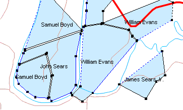
Plot View – this is where you see your neighborhoods. You have lots of control over the presentation of the various parcels. Besides being printable, this view can be exported in several graphic forms and in KML format that’s used by Google Earth. |
|
|
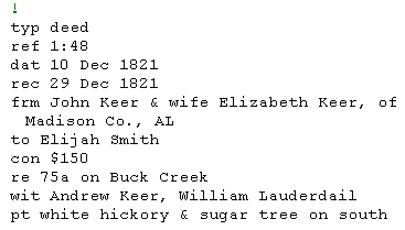
Text View – this is where you enter or modify the deed descriptions. The view also has a Notes field (not shown) where you can enter additional free text relating to your deeds. There are three ways of entering a deed into the program: the Deed Entry Form, a customizable deed template, and direct text entry. |
|
|
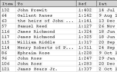
Table View – this is a handy one line summary of each deed in your deed file. The information it shows can be customized by you, and it’s sortable, too! This view can also be exported in CSV (comma separated value) format to programs like databases or spreadsheets. |
|
Key Program Features
- Enter survey descriptions and have your parcels platted
- Fit parcels together to create an ownership map
- Control the display of owner names, acreage, property corners and lines, and more
- Control the line and text color, line thickness, fill color, and fonts used in parcel display
- Filter the deeds according to specific criteria
- Search the deeds for names or other text
- Rotate parcels to correct for declination errors
- Display latitude and longitude of points on the maps
- Measure the direction and distance between points on the maps
- Export to Google Earth and CSV (comma separated value)
- Export graphic files
- Export your project work as a web site
- Print all views, including multi-page printout of the Plot View