Using DeedMapper background maps
Working with DeedMapper background maps
|
|
Direct Line Software sells optional DeedMapper-compatible maps that are used as backgrounds in the Plot View. You can move your parcels around on top of these background maps. Examples of DeedMapper maps are found in the Sample Projects and to the left. You can also use scanned or downloaded graphic images instead of our maps. While our maps come without feature names you can add your own names (annotations) to the maps (see “Dry Creek”). The maps are shipped to you by email. Map installation consists of copying the maps files into the folder that has your deed file. Whenever you open a deed file, DeedMapper automatically looks for map files in the folder that houses the deed file. If it finds map files it loads and displays them.
|
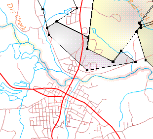
Each DeedMapper map covers an area that is roughly 14 miles wide by 18 miles north-south. Multiple maps are combined into a single map covering a larger area. You can zoom into and out the Plot View with the PgUp and PgDn keys. The program takes care of scaling your maps and parcels together in the view.
Several different map "layers" of information are available separately. The layers are overlaid to create a composite map.
• Streams
• Roads and trails
• Railroad lines
• Public Land section boundaries
• Boundaries (e.g. state and county lines, townships in the northeast)
The most popular combination of layers is Streams and Roads.
Contact Direct Line Software for additional information:
617 527-9566