Adding annotations to deeds and maps
Adding annotations to your maps or parcels
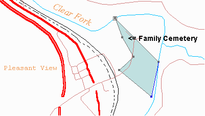
Annotations are words or comments that you want to display on maps or parcels. Use annotations to show the names of creeks or towns on maps (see the brown text above). Parcels can also have annotations to show things like the location of a cemetery or other feature of the parcel, but be sure to see the Display menu for other ways to show information on your parcels.
Annotations are attached to their parent parcel or map. When the parcel or map is moved, the annotation moves with it.
Adding an annotation
1. Go to the Plot View (F5 shortcut key)
2. Select a map or a parcel (see Selecting/deselecting items)
3. Open the Edit menu and select the Annotation command, or push the Annotation button ![]() on the toolbar.
on the toolbar.
4. Fill in the Annotation dialog box and press OK
The annotation will be shown in the middle of the screen (if it’s a map annotation) or the center of the survey (if it’s a parcel annotation).
Moving (dragging) an annotation
Click once on the annotation to select it, then drag it by holding down the left mouse button. When you’re satisfied with the location just release the left mouse button, then click it once to deselect it.
Editing an annotation
It’s easy to change an annotation. Just double click it and you’ll be presented with the annotation dialog box. Make any necessary changes and press OK.
Deleting an annotation
Click once on the annotation to select it, then open the Edit menu and select Delete. You'll be asked to confirm the deletion.