Specifying background images
Images tab (View Options dialog)
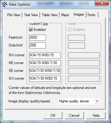
To see this dialog, open the View menu and select Options. Click on the Images tab. This tab allows you to define certain characteristics of up to two graphic files that you can use as Background Images for your deed work. Changes to this tab are temporary unless you make them permanent by performing File Save after pressing OK.
When it opens your deed file, DeedMapper also automatically loads the first two image files (of type BMP, JPG, TIF, GIF) that it finds in the same folder as your deed file. The images are typically digital topographic maps from the USGS, scans of a paper map, or information from an Internet site or a mapping program of some kind.
If you have two image files, by default they will both be placed at the same location, so one will obscure the other. To move an image, click on its corner until its border lights up. Then press the left mouse button and drag it to a new location.
Enabled - If checked, the graphic file will attempt to be displayed. It may not be displayed if certain required information is not provided (see next).
Feet/Inch - This is the scale of the map. This information is required in order for DeedMapper to display the graphic image. See Background Images for more information. See also next. If you are using a 1:24000 digital topographic map from the USGS the value to use here is 2000 feet per inch.
Dots Per Inch - This is the scanning density (dots per inch, dpi) that was used to scan the map. This information is required in order for DeedMapper to display the graphic image. Common values for scanned images are 300 dpi, and higher. The higher the density, the more the image can be zoomed into without getting grainy. See Background Images for more information. If you’re using a digital topographic map in TIF format from the USGS TopoView site the value to use here is usually 300 dots per inch.
NW corner - Optionally enter the latitude and longitude of the northwest (upper left) corner of the image. This value is used 1) by the grid tool to measure the latitude and longitude of points in the image, 2) when saving deeds in KML format for use with Google Earth, and 3) for placing GPS Points. If you don’t need these capabilities you can leave the field blank. The format for entry is Ndd/mm/ss Wdd/mm/ss, where d is degrees, m is minutes, and s is seconds, e.g. N43/15/00 W79/07/30. See Background Images for detailed information regarding this field.
NE corner – Same as above, but for the northeast (upper right) corner.
SE corner – Same as above, but for the southeast (lower right) corner.
SW corner – Same as above, but for the southwest (lower left) corner.
Image display quality/speed – If you have a high performance computer you should select Higher quality, otherwise select Faster.