GPS points
GPS Points
If you have a handheld GPS device and you’re able to walk a parcel of interest to you, you can take GPS readings of features on the parcel and then enter that information into DeedMapper’s Text View in the abstracting section of the deed’s text.
Important: this feature is available only if you use our compatible background maps, or your own background image and you’ve defined the image corners (see Background Images).
Here are two examples. The first shows the use of degrees/minutes/seconds format and the second example shows the use of decimal degree format. Note that the latitude value appears first. It must begin with N and be followed by a semicolon. The second value is longitude, and it must begin with W and be followed by a semicolon.
gps N37/34/14; W78/03/06; fallen chimney
GPS N37.345789; W78.043256; small cemetery
You can have as many GPS points per deed as you like. GPS lines must occur in the Text View prior to the metes and bounds lines (Pt and Ln).
Note: Your GPS may display values in a format other than those above so be sure to do any necessary conversion. For example, if your GPS reports North 37 degrees 24.233 minutes you must convert 24.233 minutes into minutes and seconds. Do this by taking 24 as the number of minutes and then multiplying the remainder of .233 times 60. You get 13.98 seconds which you round up to 14 seconds.
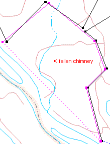
The text is optional. If present it is displayed next to a symbol that marks the indicated latitude and longitude. The text is presented in the same font and color as the text for the deed itself. For example, if the deed is set to use the standard plot style and standard font, the waypoint text will be presented using the standard style and font. If the deed uses a custom font or text color then the waypoint text uses those settings too.
Important: GPS points are associated with a particular deed. They must be within the bounds of the deed or extremely close to it. They are displayed only when the deed they belong to is displayed, so if their deed is off screen and out of view the GPS point will not be shown. If the deed is filtered out, so is the GPS point.
GPS points are similar to annotations in some ways, but differ in that they cannot be selected, rotated, deleted, dragged, etc. Their existence and location are determined by the latitude and longitude values that you provide in the Text View.